
Mesa Community College REA 281
Principles of Real Estate Law study materials
Government Rectantular Survey System
Study Guide
Following are the crib notes for understanding the government grid system.
|
Mesa Community College REA 281 Principles of Real Estate Law study materials Government Rectantular Survey System Study Guide Following are the crib notes for understanding the government grid system. |
|
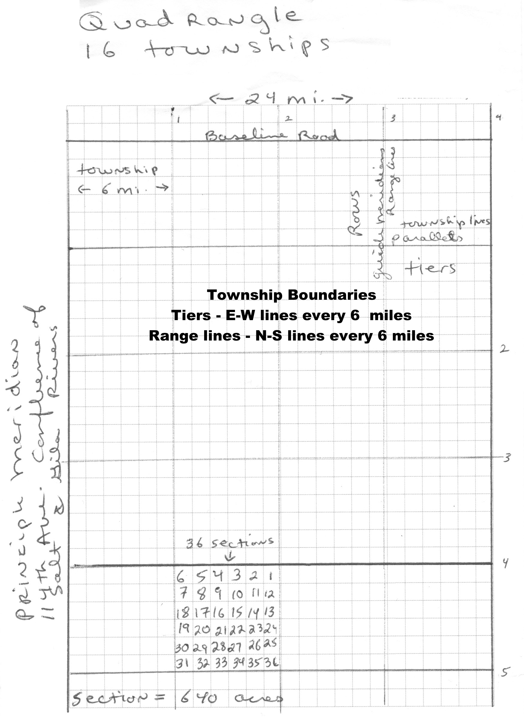
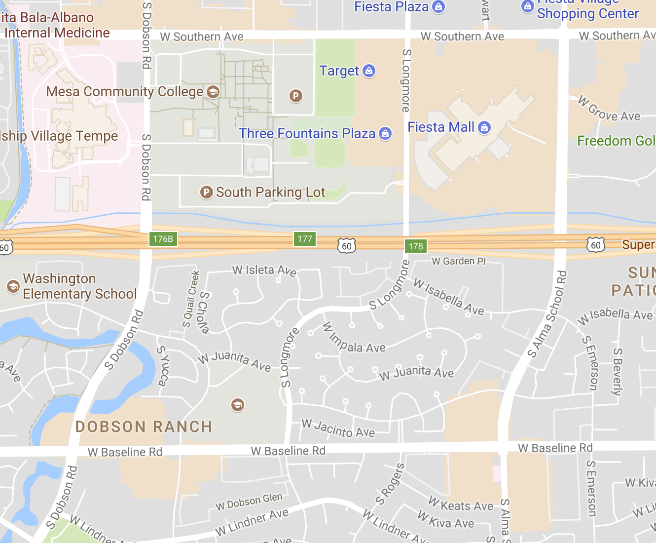
State Map—divided into quadrants by the principal baseline and meridian. In Arizona, they cross at the confluence of the Gila and Salt Rivers, approximately 115th Ave. and Baseline. This is called the G & S R B & M, aka initial point, confluence point, point of confluence, starting point. Phoenix is approximately 20 miles NE of this point. From there, gridlines are placed every 6 miles north and south, east and west. The north and south grid lines are called range lines; the east and west lines are called township lines, tiers, or meridians.Each six mile square is called a township. Quadrangles—24 mile squares known as quadrangles are divided into 16 townships that are 6x6 miles. Each township inside a quadrangle is trimmed on the north and west side by 12 square rods to compensate for the curvature of the earth. Therefore, each township contains 25 standard (full) sections and 11 fractional (irregular, not standard) sections. No township contains 36 square miles, due to trimming. Townships—6 mile squares formed by the tier and range lines. These are named according to their place on the grid, i.e. T4N R4W (tier first, then range). This is the corner furthest from the initial point. You measure the distance to a township according to both sides, i.e. 24 to 30 mi. (A shortcut is to multiply the number in the description times 6 miles, then deduct 6 miles. That gives you both sides of the township.) Townships fall into rows and columns; distance of the whole row or column may be measured the same way, i.e. 6 to 12 mi. Townships have 23,040 acres, 6 miles square, 24 miles perimeter, 36 square miles, 36 sections. Sections—These are one square mile. Each township contains 36. They are numbered according to a right to left, left to right wrap around system, 1 through 36. Each of these sections may be quartered and quartered again. The smallest quarter allowed is 2.5 acres. You measure the distance between sections in a township by counting the miles between the closest corner to closest corner of each section (unless directed otherwise), while staying on the grid lines. Sections are 1 square mile, 4 miles perimeter, 1 mile square, 640 acres. The eleven sections falling on the north and west side of the township are trimmed (fractional, irregular, not standard) sections. Quartering a Section halves the footage along the perimeter and quarters the acreage. A section is 5280 ft x 5280 ft (1 mile x 1 mile) or 640 acres. 1/2 Section is 5280 ft x 2640 ft (1 mile x 1/2 mile) or 320 acres 1/4 Section is 2640 ft x 2640 ft (1/2 mile x 1/2 mile) or 160 acres 1/4 of 1/4 section is 1320 ft x 1320 ft (1/4 mile x 1/4 mile) or 40 acres 1/4 of 1/4 of 1/4 section is 660 ft x 660 ft (1/8 mile x 1/8 mile) or 10 acres 1/4 of 1/4 of 1/4 of 1/4 section is 330 ft (1/16 mile x 1/16 mile) or 2.5 acres Smaller than this reverts to the plat map or metes and bounds system. Curvature of the Earth—To find out how the north-south grid lines compensate for the curvature of the earth, take a look at this screen shot from Google Maps. |
|
This shows the north-south streets around Mesa Community College. Note how Dobson and Alma School swing to the west to join Baseline. Baseline Road is the baseline meridian for this part of Arizona, so that's where the compensation is made. You can do an experiment - go to Google Maps and trace Baseline Road all the way across the Valley, and notice how all the large streets swing to the west at Baseline. The exact opposite of the Rectangular Governmental Survey System is the Metes and Bounds system. Metes and Bounds is the Old English system of measurements and boundaries. Informal, fast, and easy, but highly inaccurate. It uses manmade or natural monuments. Formal replaced informal. It is highly accurate, but tedious and cumbersome. It uses a benchmark as the starting point. The benchmark may or may not be on the property. The benchmark is a permanent location not subject to change in the time we do the survey. You follow directions (arcs and angles) to a P.O.B. (point of beginning). This is a point on the property. From there, you follow directions to tell you the boundaries of the property, then you end at the P.O.B. The description will look like this: "Beginning at the NE corner of X intersection, thence South 550 feet, thence East 1275 feet, which is the point of beginning (p.o.b.), thence South 850 feet, thence West 1275 feet, thence back to the place of beginning." |